Mynydd Mawr viewpoint, near Uwchmynydd
![]()
![]() Mynydd Mawr viewpoint, near Uwchmynydd
Mynydd Mawr viewpoint, near Uwchmynydd
The high ground here, at the westernmost tip of the North Wales mainland, provides views of the sea, Ynys Enlli (Bardsey) and the rest of the Llŷn Peninsula. In clear weather you may see the mountains of County Wicklow, Ireland, on the horizon.
With such extensive views, it’s no coincidence that this spot was chosen by the Victorian authorities for a coastguard lookout point here, described as a “semaphore signalling station” on a 1901 map.
 A press report in 1893 said the new telegraph wire to the Mynydd Mawr station could be useful in stormy weather as “the means of saving life upon the rock-bound coast and its dangerous spots”.
The facility was used in the First World War and upgraded c.1940, when Germany started sending bombers via the Irish Sea to attack Liverpool and other strategic targets. The new features included radar equipment, an army guard-house and a gun emplacement. It was one of several radar posts which formed the RAF’s Pen y Bryn radar station.
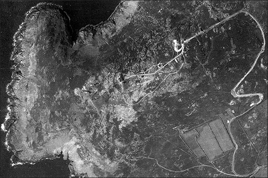
Some of the buildings still stand, while concrete bases show where others stood. The aerial photo, courtesy of the Welsh Government, shows the station in August 1945.
The coastguard left the site in 1990. Its former hut is now sometimes used by National Trust volunteers to provide information to visitors. The National Trust owns the land in this area.
South of the car park at Mynydd Mawr are the bases of three circular prehistoric huts, each about 4 metres to 4.5 metres in diameter. The base of the cairn at the summit of Mynydd Mawr dates from the Bronze Age.
Directly below the radar station there are disused limestone quarries, possibly first opened to produce lime for agriculture. From 1910 until the First World War, the British & Welsh Marble Quarries Company Ltd tried to market the stone for architectural, ornamental, monumental and other uses. The company was formed by Evan James Evans, who also operated a small barytes mine near Aberdaron.
As you enjoy the view along the Llŷn Peninsula, it should be obvious why the entire peninsula – 155 square km – was designated an Area of Outstanding Natural Beauty in 1957. The AONB team within Gwynedd Council prepares and helps to implement the area's management plan. Recent projects include conservation of "fingerpost" road signs, milestones and wells. Follow the link below for details.
With thanks to Michael Statham of the Welsh Stone Forum for limestone quarry information
Website of Llŷn Area of Outstanding Natural Beauty

